Special weather statement in effect for:
Queens County
Potential storm over the Maritimes at anytime this Fall and Winter .
A storm will likely develop and affect Nova Scotia any time during any week. While it is too soon to provide specific details on precipitation types and amounts, there is a good possibility of accumulating snow, heavy rainfall and strong winds.
Additional information will be provided as the details become more certain.
Monday, November 4, 2019


Sunday, April 29, 2018
Winter's Last Gasp
Quite interesting how quickly the seasons can change here.
On April 20th we had snow...enough to turn the ground white (mind you,it didn't stick around for very long) and by April 23rd the temps were in the mid-teens in C°.
Temps were seasonable for the past week,whatever seasonable is in these days of changing climates,so let's just say that it felt like Spring is supposed to feel with warmth and sunshine.
It appears that we are out of the cool weather that we experienced for most of April with another decent ,'seasonable',week coming up:

....but still,as a friendly reminder,these were taken by me on April 20th,2018:


Cheers,
Al
On April 20th we had snow...enough to turn the ground white (mind you,it didn't stick around for very long) and by April 23rd the temps were in the mid-teens in C°.
Temps were seasonable for the past week,whatever seasonable is in these days of changing climates,so let's just say that it felt like Spring is supposed to feel with warmth and sunshine.
It appears that we are out of the cool weather that we experienced for most of April with another decent ,'seasonable',week coming up:

....but still,as a friendly reminder,these were taken by me on April 20th,2018:


Cheers,
Al
Monday, March 12, 2018
Another storm on the way
It's been a relatively mild winter with very little snow here on the South Shore ...so far....but that is about to change with another 'Nor'easter' expected to arrive tomorrow in the late morning / early afternoon.
Statement issued by Environment Canada:


Statement issued by Environment Canada:
4:40 AM ADT Monday 12 March 2018
Winter storm warning in effect for:
Winter storm warning in effect for:
- Queens County
Heavy snowfall and high winds are expected.
An intense winter storm will bring heavy snow and high winds on Tuesday. Snow will likely change to rain Tuesday night.
A low pressure system is forecast to develop east of Cape Hatteras today then intensify as it tracks northeastward toward the Maritimes on Tuesday. The storm centre is forecast to track near the Nova Scotia Coast late Tuesday night.
Snow at times heavy is expected to begin Tuesday morning over southwestern Nova Scotia and continue through the day. At this time amounts up to 20 centimetres are possible by late Tuesday afternoon. Additional snow amounts are possible Tuesday evening before the snow likely changes to rain. Very strong east to northeasterly winds will develop during the day, and are expected to gust to 90 to 110 km/h during the afternoon and evening. These winds will likely give extensive blowing and drifting snow and could lead to power outages.
Additionally, a special weather statement is in effect for the Atlantic coastline of mainland Nova Scotia for the the potential for storm surge and damaging waves Tuesday night into Wednesday morning.
..........................................................................................................................................
An intense winter storm will bring heavy snow and high winds on Tuesday. Snow will likely change to rain Tuesday night.
A low pressure system is forecast to develop east of Cape Hatteras today then intensify as it tracks northeastward toward the Maritimes on Tuesday. The storm centre is forecast to track near the Nova Scotia Coast late Tuesday night.
Snow at times heavy is expected to begin Tuesday morning over southwestern Nova Scotia and continue through the day. At this time amounts up to 20 centimetres are possible by late Tuesday afternoon. Additional snow amounts are possible Tuesday evening before the snow likely changes to rain. Very strong east to northeasterly winds will develop during the day, and are expected to gust to 90 to 110 km/h during the afternoon and evening. These winds will likely give extensive blowing and drifting snow and could lead to power outages.
Additionally, a special weather statement is in effect for the Atlantic coastline of mainland Nova Scotia for the the potential for storm surge and damaging waves Tuesday night into Wednesday morning.
..........................................................................................................................................
Once again,we will experience strong winds which will create a storm surge and have the potential to cause power failures.
The latest precip and wind models:


Thursday, January 4, 2018
Major storm to hit NS today
Hurricane force winds.
Expect an extended period of power outages.
Temps will be above freezing for the most part.
Expect an extended period of power outages.
Temps will be above freezing for the most part.
Alerts for: Queens County
Warnings
4:54 AM AST Thursday 04 January 2018
Storm surge warning in effect for:
Storm surge warning in effect for:
- Queens County
High Storm Surge levels and large waves are expected to impact the coast.
A low pressure system east of Cape Hatteras will intensify rapidly into a major winter storm today as it approaches the Maritimes from the southwest. The intense storm will track near the Bay of Fundy tonight and into the Gulf of St Lawrence Friday morning.
During high tide this evening, water levels along the Atlantic coast will be elevated enough to cause coastal flooding in vulnerable areas. In addition very large waves coming in to the coast from the south and east will contribute to the high water and will likely cause some damage to coastal infrastructure.
Additionally near noon today higher than normal waters may cause coastal flooding in vulnerable areas of Yarmouth County.
Storm surge warnings may need to be extended to other parts of the province later today.
A low pressure system east of Cape Hatteras will intensify rapidly into a major winter storm today as it approaches the Maritimes from the southwest. The intense storm will track near the Bay of Fundy tonight and into the Gulf of St Lawrence Friday morning.
During high tide this evening, water levels along the Atlantic coast will be elevated enough to cause coastal flooding in vulnerable areas. In addition very large waves coming in to the coast from the south and east will contribute to the high water and will likely cause some damage to coastal infrastructure.
Additionally near noon today higher than normal waters may cause coastal flooding in vulnerable areas of Yarmouth County.
Storm surge warnings may need to be extended to other parts of the province later today.
High waves combined with the surge may cause damage along the coast. Coastal flooding is likely. Coastal erosion is likely in vulnerable areas. Stay away from affected shorelines. People close to the shoreline should stay on the lookout for worsening conditions. Do not attempt to travel across flooded roads as even shallow, fast-moving water can sweep a vehicle away.
Storm surge warnings are issued when water levels pose a threat to coastal regions.
Please continue to monitor alerts and forecasts issued by Environment Canada. To report severe weather, send an email to ec.weatheraspc.ec@canada.ca or tweet reports using #NSStorm.
Storm surge warnings are issued when water levels pose a threat to coastal regions.
Please continue to monitor alerts and forecasts issued by Environment Canada. To report severe weather, send an email to ec.weatheraspc.ec@canada.ca or tweet reports using #NSStorm.
4:54 AM AST Thursday 04 January 2018
Rainfall warning in effect for:
Rainfall warning in effect for:
- Queens County
Rain, heavy at times is expected. The frozen ground has a reduced ability to absorb this rainfall.
A low pressure system east of Cape Hatteras will intensify rapidly into a major winter storm today as it approaches the Maritimes from the southwest. The intense storm will track near the Bay of Fundy tonight and into the Gulf of St Lawrence Friday morning.
Snow and ice pellets will develop this morning ahead of this system but are expected to quickly change to rain over Atlantic coastal regions. Rain at times heavy will continue into this evening then change to flurries overnight. Total rainfall amounts of 30 to 50 millimetres are expected.
It is important to note that due to the frozen ground, rain may initially freeze on contact with the cold ground and very little of the rainfall will be absorbed so water pooling in low lying areas is likely.
A low pressure system east of Cape Hatteras will intensify rapidly into a major winter storm today as it approaches the Maritimes from the southwest. The intense storm will track near the Bay of Fundy tonight and into the Gulf of St Lawrence Friday morning.
Snow and ice pellets will develop this morning ahead of this system but are expected to quickly change to rain over Atlantic coastal regions. Rain at times heavy will continue into this evening then change to flurries overnight. Total rainfall amounts of 30 to 50 millimetres are expected.
It is important to note that due to the frozen ground, rain may initially freeze on contact with the cold ground and very little of the rainfall will be absorbed so water pooling in low lying areas is likely.
Localized flooding in low-lying areas is possible. Heavy downpours can cause flash floods and water pooling on roads.
Rainfall warnings are issued when significant rainfall is expected.
Please continue to monitor alerts and forecasts issued by Environment Canada. To report severe weather, send an email to ec.weatheraspc.ec@canada.ca or tweet reports using #NSStorm.
Rainfall warnings are issued when significant rainfall is expected.
Please continue to monitor alerts and forecasts issued by Environment Canada. To report severe weather, send an email to ec.weatheraspc.ec@canada.ca or tweet reports using #NSStorm.
4:53 AM AST Thursday 04 January 2018
Wind warning in effect for:
Wind warning in effect for:
- Queens County
Dangerous wind gusts causing widespread damage are expected or occurring.
A low pressure system east of Cape Hatteras will intensify rapidly into a major winter storm today as it approaches the Maritimes from the southwest. The intense storm will track near the Bay of Fundy tonight and into the Gulf of St Lawrence Friday morning.
Very strong easterly winds gusting to 100 km/h are forecast to develop over the entire province of Nova Scotia today. Over exposed areas near the coast these winds could gust as high as 130 km/h with the strongest gusts along parts of the Atlantic coast this afternoon.
Very strong south to southwesterly winds generally gusting to 110 km/h with potential gusts to 140 km/h along parts of the Atlantic coast will develop tonight and into Friday morning as the intense storm tracks north of the province.
A low pressure system east of Cape Hatteras will intensify rapidly into a major winter storm today as it approaches the Maritimes from the southwest. The intense storm will track near the Bay of Fundy tonight and into the Gulf of St Lawrence Friday morning.
Very strong easterly winds gusting to 100 km/h are forecast to develop over the entire province of Nova Scotia today. Over exposed areas near the coast these winds could gust as high as 130 km/h with the strongest gusts along parts of the Atlantic coast this afternoon.
Very strong south to southwesterly winds generally gusting to 110 km/h with potential gusts to 140 km/h along parts of the Atlantic coast will develop tonight and into Friday morning as the intense storm tracks north of the province.
High winds may cause numerous downed trees and damage may occur from blowing debris. Store or anchor objects so they are not tossed by the wind causing injury or damage.
Wind warnings are issued when there is a significant risk of damaging winds.
Please continue to monitor alerts and forecasts issued by Environment Canada. To report severe weather, send an email to ec.weatheraspc.ec@canada.ca or tweet reports using #NSStorm.
Wind warnings are issued when there is a significant risk of damaging winds.
Please continue to monitor alerts and forecasts issued by Environment Canada. To report severe weather, send an email to ec.weatheraspc.ec@canada.ca or tweet reports using #NSStorm.
Wednesday, November 1, 2017
Oct 2017 recap
We had decent weather all through October.Temps were warm and rainfall was minimal.Thanksgiving weekend was warm and the day of the dinner was spent socializing in the front yard at the homestead in the country before the feast.....ya gotta like that! ! Hallowe'en night was comfortable for the 'Trick or Treaters' ....no need to bundle up with temps around 7°C during the evening.
The leaves are dropping more now but mid-month the trees were colorful and full.Still a lot of green leaves then,too. Here's a couple taken along the Mersey in the Trestle Trail / Pine Grove Park area on Oct 14th.


The leaves are dropping more now but mid-month the trees were colorful and full.Still a lot of green leaves then,too. Here's a couple taken along the Mersey in the Trestle Trail / Pine Grove Park area on Oct 14th.


-----------------------------------------------------------------------------------------------------------------------
Not a lot happening in the skies over Oct.The annual Orionids were a bust here.The automated camera that shoots all night only picked up a few over a couple of nights......nothing at all like was advertised and expected.


I did capture a really bright Iridium flare:

and an evening pass of the ISS almost intersecting with a plane to make a somewhat interesting shot:

That's all for now.
Cheers!!
Saturday, October 14, 2017
Iridium flare
Nice and clear last night.Northern Lights were weak while I was out but did get a nice shot of one of the Iridium satellites flaring over Liverpool,Nova Scotia.


Sunday, October 1, 2017
Sept 2017 recap
Sept was a 'slow' month for sky imaging here.Clouds were an issue for 3/4 of the 30 days due mostly to Hurricanes Jose and Maria.Neither storm had any significant impact here other than a little rain,some wind and a number of days and nights of very warm and humid conditions.All that is behind us now and the month ended,as it began, with clear skies.Temps are now returning to 'normal' with daytime highs in the 20°C range and cool nights in the upper single digits.
I did have the automated Canon PowerShot A-610 set up for a few nights and caught a few stray meteors:


That's all for now.
Cheers,
Al ( https://twitter.com/AL_in_NS )
I did have the automated Canon PowerShot A-610 set up for a few nights and caught a few stray meteors:


That's all for now.
Cheers,
Al ( https://twitter.com/AL_in_NS )
Sunday, August 27, 2017
August meteors
Summer is winding down.With that comes cooler nights and clearer skies so hoping to capture more meteors in Sept with the A-610.
We have one clear night left for this month according to the forecast:

Besides the Perseids I posted previously,here's a couple of more small August meteors.The camera was looking West when it captured these:


Cheers,
Al
We have one clear night left for this month according to the forecast:

Besides the Perseids I posted previously,here's a couple of more small August meteors.The camera was looking West when it captured these:


Cheers,
Al
Monday, August 21, 2017
The 2017 solar eclipse.
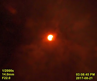
Just a partial eclipse here.Had to leave home before the peak but shot a few pics at the beginning...
taken with an Olympus E-PL1 set at ISO 50,F-stop at 22 and 1/2000 sec exposure using the stock M.Zuiko 14 to 42mm lens.The 'solar filter' is comprised of 2 exposed 35mm negatives.It worked OK.First pic is at 14mm,second at 42mm.Both are cropped.

Cheers,
Al
taken with an Olympus E-PL1 set at ISO 50,F-stop at 22 and 1/2000 sec exposure using the stock M.Zuiko 14 to 42mm lens.The 'solar filter' is comprised of 2 exposed 35mm negatives.It worked OK.First pic is at 14mm,second at 42mm.Both are cropped.


Cheers,
Al
Sunday, August 20, 2017
Perseids
Some Perseids over the past few weeks....unfortunately we were under the clouds during the peak.
The camera is currently shooting away.Maybe we'll catch a meteor or two tonight.


Cheers,
Al
The camera is currently shooting away.Maybe we'll catch a meteor or two tonight.


Cheers,
Al
Sunday, May 21, 2017
Back to better weather...and clear skies!
Haven't posted for a while....working 2 jobs and doing a few other things are taking up a good deal of my time.
Anyways,the weather has changed for the better...almost in the blink of an eye.One week ago it was cold,raining and windy.A day or so later and summer weather arrives with lots of sunshine and temps in the 30°Cs for highs.It's a little cooler today at 22°C and low humidity.One could call this a perfect day....the light breeze is an added bonus.
As with everything,all good things must end.Some rainy weather is on the way starting tomorrow evening.Temps will still remain warm.
Some pics I took over the past little while on the clear nights.Most have details included in the image:


Hoping for more clear skies throughout the upcoming summer nights.
-Cheers,
Al C
Thursday, April 27, 2017
A meteor or a flare
Taken with my Canon A-610 running CHDK...1st one is original with time stamp edited (clock was off by 1 hour),last 2 photos in the series are for reference.

A couple more shots taken over the past week or so:


A couple more shots taken over the past week or so:


And one taken while out chasing the Northern Lights....there may be a tinge of red but that may be from the terrestrial lights:

Later....
Thursday, April 6, 2017
One Week Ago - The Ice Storm
We had a major ice storm here a week ago.There were major power failures that were mostly caused by downed branches and trees.We had three outages here with the longest being about 10 hours.
Here are some pics.Most were taken when the storm was over and the sky was clearing.


Here are some pics.Most were taken when the storm was over and the sky was clearing.


Still waiting for Spring to arrive here.....maybe it will show up this weekend.
Later,
- Al
Thursday, March 9, 2017
A Clear Sky??!!
Well....we finally had a clear night sky on March 6 to 7.That's hard to believe after months of clouds.I set up the CHDK modded Canon A-610 and shot 252 sequential shots from 8:45PM to 5:18AM.Picked up a few possible Lyrid meteors and the early morning ISS pass.
 A possible Lyrid
 Another possible Lyrid
 The ISS
All shots were 1 minute @ ISO 1600, 7.3mm


All shots were 1 minute @ ISO 1600, 7.3mm
A timelapse of all 252 frames.
That's all for now.
Sunday, February 19, 2017
A better week ahead
After two significant snowstorms only days apart last week it looks like this week may be somewhat better and maybe some of the meter deep snow will melt.

In the meantime,I have my backyard buddies to keep me entertained.


That's all I have for now.
Have a great week.
-Al

In the meantime,I have my backyard buddies to keep me entertained.


That's all I have for now.
Have a great week.
-Al
Sunday, February 12, 2017
Batten Down The Hatches
Big snowstorm on the way.Looks like tonight and tomorrow will be a bit nasty.
4:28 AM AST Sunday 12 February 2017
Blizzard warning in effect for:
Blizzard warning in effect for:
- Queens County
Blizzard conditions with gusty winds and persistent visibility near zero in snow and blowing snow are expected or occurring.
A low pressure system will form south of Cape Cod this evening and rapidly intensify overnight as it approaches Nova Scotia. Snow at times heavy will develop in the far west of the province near midnight tonight then spread northeastward reaching northern and eastern regions Monday morning, and Cape Breton near noon on Monday. Very strong east to northeast winds will accompany this storm with gusts between 90 and 110 km/h expected, which will give extensive blowing snow with frequent whiteout conditions. Total snowfall amounts by Monday evening will range from 30 to 60 cm for the western portions of the province, 20 to 30 cm for northern and eastern regions and near 10 cm in Cape Breton. Additional significant amounts are likely Monday night and into Tuesday morning for northern and eastern Nova Scotia and Cape Breton.
A low pressure system will form south of Cape Cod this evening and rapidly intensify overnight as it approaches Nova Scotia. Snow at times heavy will develop in the far west of the province near midnight tonight then spread northeastward reaching northern and eastern regions Monday morning, and Cape Breton near noon on Monday. Very strong east to northeast winds will accompany this storm with gusts between 90 and 110 km/h expected, which will give extensive blowing snow with frequent whiteout conditions. Total snowfall amounts by Monday evening will range from 30 to 60 cm for the western portions of the province, 20 to 30 cm for northern and eastern regions and near 10 cm in Cape Breton. Additional significant amounts are likely Monday night and into Tuesday morning for northern and eastern Nova Scotia and Cape Breton.
Saturday, February 11, 2017
Storm on the way / Penumbral eclipse
So...another storm is on the way.The models are showing the possibility of 70cms of snow from this one starting in the wee hours of Monday morning and persisting all day.Not looking forward to that but IT IS winter.
Last night we saw a penumbral eclipse.Unbelievably,it was relatively clear and viewing wasn't bad at all....except it was a bit chilly outside.That's why they make winter coats,though,and you can't beat a Columbia for winter wear!!

A short post but that's all I have for now.
Cheers,
Al
Last night we saw a penumbral eclipse.Unbelievably,it was relatively clear and viewing wasn't bad at all....except it was a bit chilly outside.That's why they make winter coats,though,and you can't beat a Columbia for winter wear!!

A short post but that's all I have for now.
Cheers,
Al
Subscribe to:
Posts (Atom)
-
Special weather statement in effect for: Queens County Potential storm over the Maritimes at anytime this Fall and Winter . A storm will lik...
-
 We had decent weather all through October.Temps were warm and rainfall was minimal.Thanksgiving weekend was warm and the day of the dinner w...
 -
 Quite interesting how quickly the seasons can change here. On April 20th we had snow...enough to turn the ground white (mind you,it didn...